Tools to Navigate the Fire Season in Alaska
Tom George, AOPA Alaska Regional Manager
We are now firmly into the wildfire season in parts of Alaska. As the snow goes away, and the landscape dries out, smoke will invariably follow. As aviators, this means it is time to watch out for active fire fighting operations, as well as considering the potential impact of smoke during flight planning. Fortunately, there are ways to “navigate” fire season using some new tools to help manage the associated risks—let’s explore them.
Fire Traffic Areas
While we all learned about Temporary Flight Restrictions (TFRs) during flight training, there is another type of airspace that was not included in those lessons—the Fire Traffic Area (FTA). This is an airspace construct used by the agencies that conduct aerial firefighting operations, to manage their aircraft and crews when battling a wildfire.
When an agency responds to a wildfire with aerial assets, they define a circular column of airspace around the center of the fire. It extends from the center out to 12 nautical miles and reaches several thousand feet above the elevation of the terrain (See Figure 1). Aircraft engaged in the suppression effort are required to coordinate with the initial attack aircraft orbiting overhead managing the operation. The challenge is this airspace is transparent to those of us not engaged in the operation, who happen to be flying in the area. Remember, this is not a TFR! If the fire suppression effort goes on for an extended period, a TFR may be established, at which point a NOTAM will be issued, and pilots would learn about it from Air Traffic Control, Flight Service or while using online flight planning programs. But even without a TFR, there is a way we can learn what is going on. In Alaska, the fire suppression agencies use a common tactical frequency, 128.45 MHz. If you see smoke, it would be a good idea to listen on this frequency to determine if an aerial operation is underway. Traffic on that frequency will clue you in to the nature of the operation, which could involve deploying smoke jumpers, directing aerial water or retardant drops, helicopter operations, etc. Avoiding the area might be the best and safest bet, but identifying your position and altitude on the tactical frequency will let the fire crews know you are in the area. If traffic permits, they may be able to help you safely transit the FTA without interfering in their operations.
Duane Morris, Coastal Region Aerial Supervisor for the Alaska Depart of Natural Resources recently gave an excellent seminar on FTAs at the Great Alaska Aviation Gathering. He described how they are used and the nature of aerial wildfire suppression operations. For more information on this topic, see the article from the DNR’s website that gives more details on their use, and how to communicate if you find yourself in the vicinity of an active fire operation: https://bit.ly/4cgP4qh
Finding our Way through the Smoke
Even at some distance away from active fire suppression operations, smoke generated from a wildfire can make it challenging for VFR navigation. In addition to our normal sources of weather for preflight briefings, there are some new online products to help pilots anticipate where they may encounter smoke along a planned route of flight.
First is an experimental product developed by Colorado State University’s Cooperative Institute for Research in the Atmosphere. It allows pilots to look at a cross-section along a route they are planning to fly. Initially this product was designed to show where clouds could be expected, and whether to anticipate icing conditions. More recently, they have added an input from an atmospheric model that forecasts smoke concentration. In addition to viewing clouds, icing conditions and the freezing levels, you may now see a “smoke” forecast along your chosen route: (See example in Figure 2) https://aviation.cira.colostate.edu/define-custom-cross-section
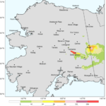
A second tool was developed by the University of Alaska Fairbanks, that looks at the concentration and distribution of smoke from active wildfires. This web-based product uses the location of fires and predicts the areal extent of smoke up to 72 hours based on different atmospheric parameters (See example in Figure 3). Check this out as another source of information during preflight planning: http://smoke.alaska.edu/
Armed with information about FTAs and new products to help predict where you may encounter smoke enroute, let’s keep pilots, passengers, and firefighters safe while making the most of the summer flying season!
Tom George serves as the Aircraft Owners and Pilots Association’s Regional Manager for Alaska. He resides in Fairbanks and owns a Cessna 185. He may be reached at tom.george@aopa.org or 301-695-2092.
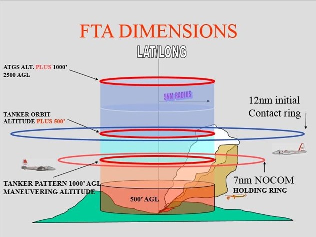
^Figure 1. Depiction of a Fire Traffic Area, an airspace structure used by the agencies that conduct aerial wildfire suppression activities. (USFS diagram)
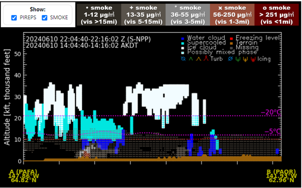
^Figure 2. The Cloud Cross Section Product from Colorado State University’s Cooperative Institute for Research in the Atmosphere now includes information on forecast smoke concentrations, which may be toggled on and off interactively. During this period, visibility due to smoke was reported as low as two and a half miles along this route.
^Figure 3. A snapshot of the UAF Smoke product showing the forecast extent and concentration of smoke. This interactive product provides a 72-hour animation of forecast conditions.